


Latest news and media

The Vendée Arctique starts, the first solo race qualifying for the 2028 Vendée Globe
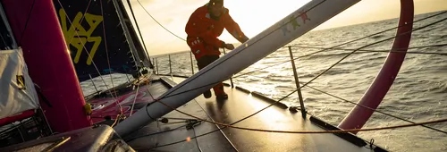
The Vendée Arctique – Les Sables d’Olonne has now set sail! This Sunday at 1.02 pm (French time), the nine skippers competing crossed the starting line in a light southerly breeze, blowing at between 4 and 7 knots. In these light conditions, the fleet remained particularly close together as the…


Vendée Arctique - Les Sables d'Olonne village in Les Sables d'Olonne is open
Since this weekend, the Vendée Globe spirit has been in the air in Les Sables d'Olonne! The Vendée Arctique village opened to the public on Saturday. In one week, on Sunday, June 7, nine skippers—including three women representing four nationalities—will compete in their first solo qualifying race…
discover the upcycled luggage collection


THE STORY CONTINUES: SODEBO EXTENDS ITS MAJOR PARTNERSHIP THROUGH 2028
A long-standing partner of the Vendée Globe, Sodebo is extending its commitment through 2028, confirming the strength and longevity of a relationship that has been built over more than 20 years. Beyond the flagship race, Sodebo is also involved in the associated events, the Vendée Arctique – Les…
U de Vendée has extended its commitment as Official Supplier to the Vendée Arctique and the Vendée Globe

Oliver Heer unveils his IMOCA Embrace The Challenge
Launched in its new colours and now renamed Embrace The Challenge, the former IMOCA Teamwork-Team Snef is embarking on a new chapter with Swiss sailor Oliver Heer.
Les Brioches Fonteneau, official supplier for the Vendée Globe
Vendée Arctique announces the first names on its sporting line-up

Pierre-Louis Attwell officially launches his 2028 Vendée Globe project
A new adventure is beginning for Pierre-Louis Attwell. Having cut his teeth in the Class40 series, the skipper has launched his IMOCA RESILIENT – formerly known as Lazare – in Lorient, with Tanguy Le Turquais (17th in the last Vendée Globe) at the helm, thereby officially kicking off his campaign…
SkipperGilou wins the first leg of the Vendée Globe eSeries

Ambrogio Beccaria, “Allagrande” as a mantra
If you thought Allagrande was the name of a partner, think again. In Italian, “alla grande” means “to the max”, “in a big way”, “successfully”. A mantra that perfectly sums up Ambrogio Beccaria's state of mind. After making his mark in the Mini Class and then the Class40, the Italian skipper joined…
Masa Suzuki has acquired the IMOCA on which Louis Duc competed in the last Vendée Globe

One year later: major scientific findings thanks to the skippers’ commitment
The Vendée Globe came to an end in March 2025. A year later, the time has come to assess its full scientific significance. One thing is certain: the 2024–2025 edition will be remembered for the unprecedented commitment shown by the skippers, who were fully dedicated to advancing our knowledge and…

Vendée Globe eSeries: here we go!
With just over two and a half years to go until the start of the 2028 Vendée Globe, the adventure is already underway... online! In partnership with Virtual Regatta, the Vendée Globe is launching a virtual round-the-world race in three stages, spread over three years. This unique immersive…
Armel Tripon, back with a competitive, responsible and solidarity-driven project
THESE SKIPPERS AIMING FOR VG2028 - Part 4 of 5. While we know that we can eat yoghurt that is a few days past its use-by date, we are less aware that we can build a boat out of carbon fibre that is past its expiry date! Yet this is exactly what Armel Tripon, skipper of Les P'tits Doudous, an…
Oliver Heer launches his 2028 campaign aboard a foiler
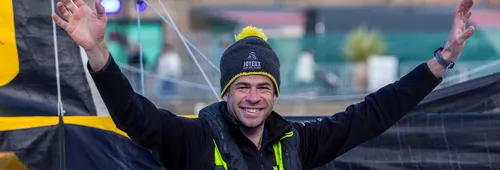
Nico D’Estais, the joyful story of the skipper with the yellow boat
THESE SKIPPERS AIMING FOR VG2028 - Part 3 of 5. A former business strategy consultant in Paris, Nico D'Estais swapped his suit and tie for a sailing jacket several years ago, in order to focus on ocean racing. After two Mini-Transat races and four years in Class40, he is taking a new step…


